
Cities: Skylines is a city-building game in the vein of SimCity that was first released in 2015, and has been filling my long winter nights ever since. As is typical to most casual city-builders, the game puts you in the role of a city’s mayor with near-absolute power. You’ll never get voted out or need to deal with city boards. The only thing restricting your imagination is how much money you have in your coffers and how benevolent you want to be to your digital denizens.
Hidden within a treasure trove of mods and assets for this most time-sinking of hobbies is a map of Milwaukee. Developed by user Fusksalad, this digital canvas replicates most of the geographic features of modern-day Milwaukee, true to scale, from UWM in the north to Oak Creek in the south. (Sorry, Shorewood, you just missed the cut.)
Upon seeing this, I downloaded the map immediately.
I now had a blank slate, a digital Good Land, and considered the opportunities in this map which would quickly become My Milwaukee. I started to wonder if the city I was building would start to take a form similar to the one I’ve come to know and love. Mostly, I was curious to see if I could manage this city to grow to a size of 600,000 citizens, just enough to surpass Milwaukee’s population as of the last census. The real city took almost 175 years to get to this point. How long would it take my simulated version?
My next thoughts led me to question if I would find any insights into the historic development pattern of Milwaukee? Were the forces that shaped our city more geographic or economic in nature? Would my simulated citizens complain about the streetcar for years on end?
Free from the shackles of time, space, and politics, I decided to use Cities: Skylines as an in-no-way-scientific means to find out. I loaded up the map, named it Cream City, and started to play.
January 1, 2020

The game starts you off on a date that used to be in the future, with a blank parcel of land next to Lake Michigan. (Blank, that is, except for I-94, the Hoan Bridge, and some train tracks in the Menomonee Valley.) I see landmarks such as Lakeshore State Park and the Marquette Interchange have already been modeled. I consider for a second removing the freeways for realism’s sake but decide against it since 1) this virtual version didn’t require demolishing mature, walkable, stable, and heavily minority/immigrant neighborhoods to exist, and 2) the game’s code requires them to populate the city. I keep them in place as the original artist intended.
So, unlike Milwaukee’s early immigrants, these 21st century settlers will be arriving by car. I connect the fledgling city to the Lakefront Spur, and people start flooding in. (They must have read one of those articles “discovering” how great this place is.)
While Solomon Juneau originally settled near the corner of Water and Michigan, my early pioneers appear to prefer the land near the confluence of the Milwaukee, Menomonee, and Kinnickinnic Rivers. The first houses are built at the intersection of Erie and Broadway, and the neighborhood of Juneau is born.
August 25, 2020

As a strong commercial economy is developing on Broadway, demand for industry to make those products is high. With direct access to shipping yards both by rail and water, and to concentrate pollution away from the residential areas, the city’s first factories begin to rise across the river. By the end of the year, nearly 2/3 of Cream City residents work in the industrial neighborhood of…let’s name it…Walker’s Port.
February 27, 2021

The promise of high-paying jobs draws an influx of residents. Demand for housing spikes. The western edge of Walker’s Port becomes a blue-collar community whose residents can walk to work while the executives begin to build houses on the western side of the river. The St. Paul Avenue Bridge connects the new, highly affluent, neighborhood of…eh, call it, Kilburnetown…directly to the industrial sector while keeping a green barrier between them.
June 11, 2022

Demand for more and better goods in the ritzy part of town brings traffic on the only bridge between Kilburne and Walker’s Port to critical gridlock. Industry cannot ship finished goods to stores, commercial districts begin to suffer. Trash collection lags because the trucks can’t make it from the Port out to the neighborhoods. A train takes out three donut trucks in the city’s worst traffic catastrophe to date. The city must take out a high-interest loan to build another bridge between Kilburne and Juneau, because the state won’t help. Upon the bridge’s completion, industrial traffic is still heavy but at least commerce can continue between the two neighborhoods. To reflect the importance of this new connection, this road is named Grand Avenue. No Bridge War in this town. That’s a shame, since everyone likes a good reconciliation story.
Learning a lesson in traffic control, the city builds a bridge across its river at every fourth block. Traffic becomes less of an issue; cost of maintenance becomes more of one.
July 11, 2022

Unable to annex more land (both due to the restrictions the game imposes as well as my lack of funds), the area around Grand Avenue is up-zoned. Demand for housing close to the city center is apparently as strong for digital Millennials as it is for real ones. Residential towers spring up seemingly overnight. With a denser, more centralized tax base, the city’s budget crunch is alleviated. Grand Avenue is widened into a boulevard to reflect its name and to support its new function as the city’s major axis.
November 1, 2022
The city’s elite suggest that now is the time to establish the first institute of higher learning, ideally close to their West Side neighborhood. As the city to the east is becoming landlocked, Grand Avenue is extended west and the university is placed on top of a hill overlooking Kilburnetown. The school’s sports team proudly names themselves the Hilltoppers, even though it’s a little on-the-nose. Population: 25,000 (5% of goal).
June 23, 2024

Cream City, after adding residential districts to the north and west, has five distinct and readily identifiable districts. Now that the city spans from Greenfield Avenue on the south to Brady Street in the north, it’s just slightly too far for the citizens to walk or bike everywhere, and vehicular traffic increases substantially. I inaugurate the first bus system to ease congestion between the residential neighborhood of Juneau and the industrial one of Walker’s Port. The buses promptly get stuck in rush-hour traffic. Population: 90,000 (15% of goal).
June 24, 2024
South 1st and 2nd Streets become transit corridors with bus-only lanes (which makes more sense than an East-West corridor, since at the moment there is nothing west of 10th Street to connect to). Everyone promptly uses these open lanes. The buses get stuck in traffic again.
October 20, 2024
After adding both hard and soft barriers to the HOV and bike lanes, the complete streets renovation of 1st and 2nd Streets successfully reduce traffic congestion to acceptable levels.
May 20, 2025
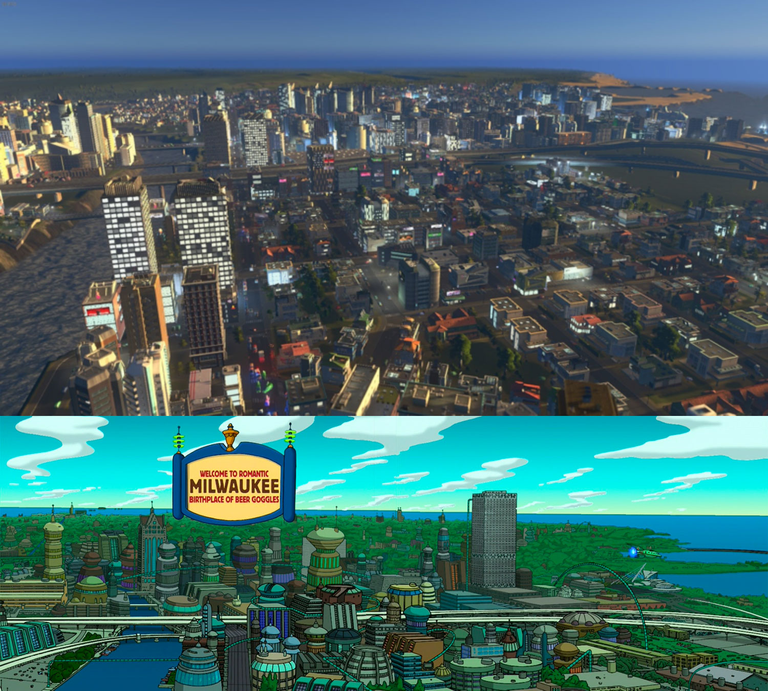
Grand Avenue has exploded in the last few years. Due to the way the game developers programmed high-density areas, the city is looking less like its current self and more like Futurama‘s vision of Milwaukee in the 31st century. No sign of the Sweethearts factory, though. Guess it’s too early for it to become the Most Romantic City on Earth. Population: 150,000 (25% of goal).
April 16, 2026

The introduction of a cruise ship port on Veteran’s Park causes the land east of Prospect Avenue to populate with new skyscrapers; luxury condominiums and high-end hotels tower over the lakefront. Now, in reality this can’t happen due to the state’s historical Public Trust Doctrine that requires any land reclaimed from Lake Michigan to be used for (intentionally vaguely defined) public use, but no such laws appear to exist in the simulation. Downtown’s public waterfront falls to the tourism industry, but receives a sizable new tax base.
January 1, 2031
Five years pass without major crisis. The strong industrial economy of the city allows it to expand quickly to its northernmost boundary. Since no further expansion occurs north of this line, the city aptly names it North Avenue.
January 2, 2032

The University celebrates 10 years of Hilltopper Pride. The city also loses population for the first time ever. Statistics show that the majority of graduates now decide to utilize their advanced degrees elsewhere. While the industrial and tourism sectors have only improved, the city’s first generation of professionals have nowhere to begin their careers. Some industries begin to specialize to take advantage of this new contingent, but it’s not enough. Downtown’s residential towers begin to empty out. The city forms a task force to battle this Brain Drain. It’s decided to provide massive investment in public/private partnerships between universities and local businesses so students don’t have to leave immediately upon graduation. Incubators and startups follow. The university builds eight new buildings to support it all. Population: 125,000 (20% of goal).
2035
Demand for professional offices outpaces the demand for housing in the city’s core. Downtown makes the messy transition from residential neighborhood to financial center. Highly skilled, highly paid workers flood into the North Shore communities, far away from the traffic and noise of the industrial south. The previous residents who were displaced begin to look for housing elsewhere. The smog-choked undeveloped areas around Walker’s Port and the Water Reclamation Facility begin to fill in with housing for people who have nowhere else to go. These neighborhoods begin to form in the Inner Harbor and Kaszube’s Island communities.
The growth of the city continues apace. The increased runoff from the water reclamation facilities start to overwhelm the natural flow of the rivers, and pollution begins to foul the waters of the inner harbor. Property values along the waterfront plummet. Those who can, sell. Those who can’t, start becoming ill. Dams are installed on the Menomonee and Cream City Rivers to protect the city’s supply of fresh water (well, everything outside downtown anyway).

While the harbor becomes increasingly polluted, the city starts to run out of clean drinking water and power. Usage reduction policies are implemented but don’t improve the situation as the growing population continues to outpace the supply. The city annexes Bay View (by which I mean the game unlocked another section of the map) in an attempt to solve the city’s two most pressing issues with a single action: annexation provides the property rights to dredge and expand the southern end of the KK River, and the additional water rights allows me to build a Denmark’s amount of offshore wind turbines. The flow of the river increases and begins to push the polluted water out to the lake (which is kind of what the city actually ended up doing before there was coffee on the lakefront). Problem solved? Population: 200,000 (33% of goal).
2037

I’ve hit an interesting road block. Pollution is down, services are humming, the schools are highly performing, tourists are flocking by the shipload. Companies can’t wait to find property in my city, even with a high corporate tax rate. So what’s the issue? People are just not moving into Cream City like they used to. Those who do love it and plant roots, but domestic immigration has run dry and all of the demand for commerce and industry is creating a major problem: companies are shutting down because they cannot find enough employees. There just are not enough people coming by ships, trains, and automobiles. Cream City needs an airport. The only space large enough is in the southwestern corner of the map in a recently annexed town called Lake. Tarmac is laid, an airport is built, and Cream City is open to the world. Population: 250,000 (42% of goal).
2040

Population growth is more difficult to gain and sustain now. All adjacent townships have been annexed. All subdivisions have been zoned. All land has been developed.
I’ve noticed something unique to the development pattern of cities on bodies of water: they can’t expand into the water. Perhaps this is obvious, too obvious to have to think about, but cities like Paris, or London, or Houston, or Indianapolis, or Columbus, can expand inexorably outwards in ever-widening rings, where developments can be equidistant from the city center in all directions. I suddenly feel hindered by the fact that I’ve completely lost the ability to expand to the east.
While the water is beautiful, I can’t grow the city on top of it. No matter. I accepted this challenge when I started on a lake. The water gives the city its purpose. The simple fact is we’ve built out. It’s now time to build up. I begin to up-zone stable near-downtown locations in the hopes that the successful neighborhoods will stay that way after they quadruple in density.
2041

My city functions as a funnel. Just like rain in a watershed, people are drawn to the lakefront from the north, west, and south. They all want to be there at the same time, and no amount of freeway expansion will support them once they all converge. Then, the only way out is back the way they came.
I’ve stumbled upon another attribute of cities on a body of water: they create the perfect conditions for rush hour.
Due to overwhelming demand, and overwhelming traffic, Cream City gets its first subway system. Unlike the real city’s proposed subway system, this one is successful.
While these geographical boundaries make it frustrating for alleviating traffic, the historical development of the city allows for a very efficient subway layout. While the first line ran east-west in order to connect the city center to the new stadium, the second line became the primary trunk of the line. It runs down 1st Street all the way to the southern city line and back up 10th Street to the north. Because the city is exactly twice as long as it is wide, this simple configuration connects 90% of the city’s commercial districts, half of its residential neighborhoods, and all of the city’s universities. Traffic levels along each of Cream City’s two major axes halves while pedestrian traffic in commercial districts double. Population: 300,000 (50% of goal).
February 4, 2048

The city’s population craters. Due to a combination of factors, the population drops 80,000 in a single year. The KK River Reclamation Project from 15 years ago simply pushed the pollution problem downstream (literally). The rivers are once again polluted, and a complete rebuild of the water treatment facility empties the city’s coffers. Simultaneously, the city’s pioneering citizens all retire while their grandchildren (now the youngest, most highly educated generation so far) leave the city in search for better careers, again. Must be a generational thing. The city’s manufacturing crumbles due to a lack of employees as well as customers. Thousands of buildings are bought in order to be razed. Resulting stable population: 163,564.
March 1, 2058

Zoning responds to the city’s newest demands instead of protecting its historical use. The city survives, but emerges with scars. Whole sections begin to take on a new life. Lofts and offices sprout up where factories used to bloom smoke from their stacks. Urban farms reclaim blighted properties throughout residential neighborhoods and along old commercial districts. The city has suddenly become “hip” again, and the downtown core explodes. Population: 450,000 (75% of goal).
January 1, 2070
On the 50th anniversary of Cream City’s founding, the last of the city’s original factories shuts down and the land gets rezoned as office space. While the factories provided the highest density of jobs and tax base the city had ever seen, it was impossible to maintain the infrastructure needed to support the final factory’s near-downtown location as the city grew. Also, the traffic and pollution it generated was drawing ire from surrounding neighborhoods. The once industrial city has completed its outsourcing of factories to its suburbs.
July 8, 2090

The Inner Harbor completes its 40-year transformation from shipping and logistics hub to a super-high-density multi-use neighborhood. The population of this megadevelopment alone houses what was once the population of the entire region. Bay View resists this pull towards modernization; Bay Street demarcates a line where 60-story towers give way to bungalows and five-story apartment blocks. Population: 550,000 (92% of goal).
January 27, 2120

Morning dawns on day 36,527. Exactly one in-game century later, my virtual Milwaukee is the same size as the real one, but is represented in a far different form. In this strange alternate reality where a city of 600,000 looks and feels like a city six million, I spend a few minutes looking for vistas and landmarks that might remind me of home. In this digital city I had spent the last two months building, I suddenly feel lost in the forest of skyscrapers. Is this city more a Chicago? Hong Kong? Tokyo? Ultimately, I find my city again in the place it all began: the landscape. I find some familiarity where the city meets the lake. Where the river cuts a canyon through a great wall of architecture. Where bridges demarcate one neighborhood from another.
Building my digital Milwaukee into a massive metropolis was a difficult task that reminded me that our city has been built through the individual efforts of millions of people over decades of hard work. But the lesson that stuck with me most is that no matter what shape our city eventually takes, the rivers will always lead you downtown, and the lake is always to the east.
Exclusive articles, podcasts, and more. Support Milwaukee Record on Patreon.
RELATED ARTICLES
• Come fly with me: Seeing Milwaukee from above via Microsoft Flight Simulator